It’s cold and there is fresh snow on the ground, but it’s Colorado, so the sun is shining and it’s a perfect day for a hike. There’s too much snow for the mountain bikers and not enough for the snowshoers so I get the trail all to myself. That’s exactly how I like it.
Fluffy Dog Leads the way.
Snow blanketed boulders.
A glimpse of Mount Bierstadt through the trees.
With my faithful companion, Fluffy Dog, I set out on the trail to finally finish Section 3 of the Colorado Trail. The trail starts at the Little Scraggy Trailhead and rolls through ponderosa pine forests. It winds around the sides of hills and up and down drainages until its terminus at Rolling Creek.
Rocky peaks, composed of well worn rubble dominate the landscape. The lower reaches are strewn with boulders wearing blankets of snow. Remnants of ancient peaks, they are reminders that the mountains are no more eternal than we are, just longer lived. Now and then, there is a a glimpse of the snow capped mountains through the trees.
Pillows of snow rest on evergreen brances
Granite hills typical of the area.
There’s a gun range on this section of the trail. No one was out shooting in this weather though.
The cloudless sky is a shade of brilliant blue that I’ve only ever seen in winter. The sun throws long shadows, even at midday and it’s low angled rays glide over the snow making it sparkle like precious gems. The stark white of the snow contrasts sharply with the conifers making the green needles and the red bark of the ponderosas appear deeply saturated. Here and there the trees let loose a silvery cascade of snow dust. I stop and watch the show until a nearby tree decided to loose it’s cold, shimmery gifts upon my head.
The going is slower than usual because of the snow, but I don’t mind. There is something extra special about hiking after a fresh snowfall. With the crystalline carpet muffling the rustling of the trees and brush, the silence overwhelms the senses. Even the streams are quiet. No babbling brooks chattering on their course, there is only a muted glug, glug as the water makes it’s way under the ice. Punctuating the silence are the sounds of mountain song birds, clearer and brighter than what you hear in summer, and a lone woodpecker is tap, tap, tapping in search of grubs.
And, oh the happy puppy dog! He’s unfettered to frolic freely in the snow. He’s bounding through the forest after who knows what. Oh look, he found a deer leg. Hope the critter that left it isn’t still around.
It takes some route finding to find my way through the forest with the trail obscured by snow, but the path is well worn and the depressions left by thousands of footsteps are not too hard to follow. I make my way through this cold, white Eden contemplating all and nothing. The landscape is beautiful and silent and the peace it brings my soul is unmeasured. I leave this place and return to the bustle of “real life” but it lingers in my mind and I am restless and anxious to return to the woods to find that peace again.
A little synchronicity happened in our schedules allowing Marybeth and I to embark on a short backpacking trip to tackle segment 10 of the Colorado Trail. It was a good chance to test out our gear and have a little adventure. We started our trek in the great little town of Leadville, where we met up and had dinner at the Tennessee Pass Cafe. I popped into the Leadville Outdoors & Mountain Market to pick up a dehydrated meal for our trip and ended up walking out with a new air mattress and a bunch of maps. The Market is a small but well-curated shop and the owner was very helpful and knowledgeable about her products. I can definitely recommend stopping in if you’re in the area and need some gear.
Fluffy Dog along the trail. Most of the trail is nicely shaded in pine forest.
Segment 10 of the Colorado Trail meanders through a pine forest along the base of Mount Massive, and aptly named 14er that is the second highest mountain in Colorado. There are two long up climbs going either direction on the trail. We started from the Mount Massive Trailhead, hiking “backwards” from the way most people choose to do it. The grade is not too bad on the legs and lungs (and about the same whichever direction you choose), though I think we both were a very happy when we completed the second uphill portion. Water crossings are abundant which made this a good section to go lighter on the amount of water in our packs and I didn’t need to carry extra water for Fluffy Dog which was a welcome change from most of my hikes. The trail winds mostly through pine forest and grants you occasional glimpses of Mount Elbert (which is right next to Mount Massive). After 10 miles on our feet, we found a good campsite at a large clearing with views of Leadville and the surrounding hills just inside the Mount Massive Wilderness.
Fluffy Dog is guarding the tent.
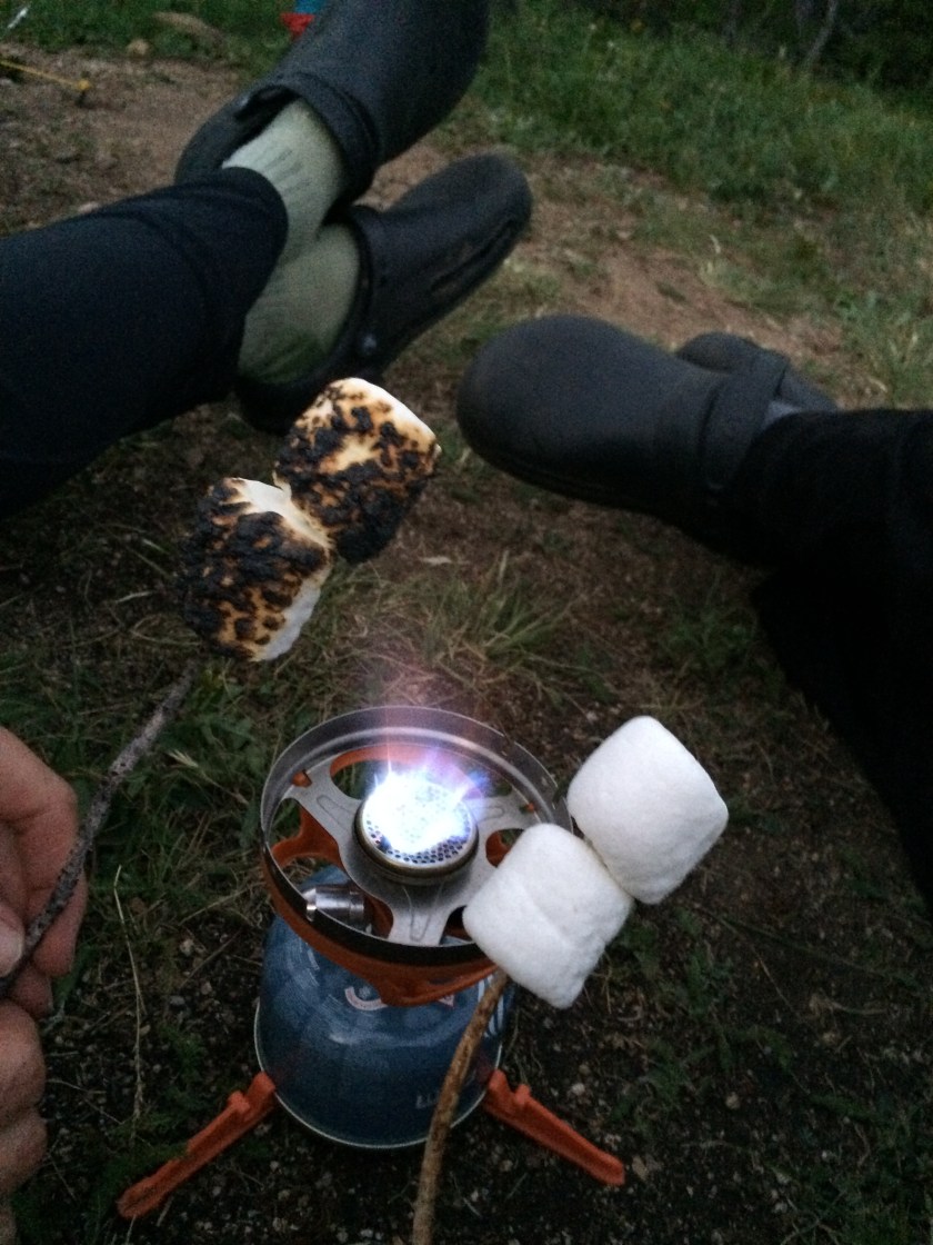
The lack of good rain this summer and subsequent burn ban meant we couldn’t build a campfire, so we made quick dinners from our dehydrated meals. It would have been perfect except we were swarmed by mosquitoes for a couple of hours before the sun went down. We took shelter from the pesky bugs in Marybeths tent until they settled down for the night. We broke out the campstove again to toast marshmallows for ‘smores, my favorite camping treat.
You can enjoy ‘smores, even if you can’t have a campfire!
While Marybeth and Fluffy Dog spent the night in her tent, I brought along my hammock and rainfly for a trial run. In one night, I’ve become a hammock camping convert! I spent a very comfortable night (even when it rained) with the exception of my sleeping pad shifting. A new sleeping bag with a pad holder is now on my wishlist, along with a bug net.
My morning view from my new favorite piece of gear, my hammock!
My pack weighed in at 28 pounds including 1 liter of water and all my food. I’d like to get that pack weight down a bit (under 20 pounds if I can) when my budget allows buying lighter gear. I have a toasty warm sleeping bag, but it weighs in at 4 pounds and takes up an extraordinary amount of pack space. A lighter, smaller sleeping bag is first on the list! Fluffy Dog is also going to learn to carry his own food, dog booties, some of his water and few other pup supplies. His gear and food (not counting water) adds nearly 3 lbs to the pack so I’ll be searching for a pack for him soon!
Fluffy Dog got to take it easy this trip, but soon he will be outfitted with his own pack.
I’m loving my Osprey pack (3 lbs) which is big enough to carry all my gear, but not terribly bulky. My spur of the moment purchase of a Thermarest NeoAir sleeping pad was a welcome upgrade from my old foam pad. I cut the foam pad down to Fluffy Dog size so he could have his own backcountry dog bed. My trusty Down Under oilskin hat, my trekking umbrella and my versatile shemya, round out my 3 favorite pieces of backpacking gear.
All my gear. Note the size of my sleeping bag! It’s definitely time for a smaller one!
We packed up our gear the next day and had a quick 3 mile hike to the Timberline Trailhead. It was time to get back to civilization and our jobs (so we can buy more gear!). We’re already dreaming of our next journey!
But first, a few more pics…
Marybeth and Fluffy taking a break.
There are a lot of tree blazes marking the trail in this segment.
Hitting the trail again, I backtracked to Section One of the Colorado Trail and tackled it in two very different days of hiking.
June 3, 2016 – 16.2 miles. Laced up my hiking boots and packed up plenty of snacks and water for what I knew was going to be a long, steep, and mostly dry hike. The plan was to start from the South Platte River and hike 8.1 miles to Bear Creek and then back. The first 4 miles are switch backs up and over a rocky ridge. It was definitely strenuous going up, but my legs were fresh and the weather was lovely. Once you gain the ridge there is a beautiful view of the valley bellow. Another 4 miles and 1000 feet of elevation loss, brought me to the first crossing of Bear Creek, a nice place to have a snack and refill the water bottles before turning back. Fluffy Dog was very happy to have a little water to splash around in. The climb back up the ridge wasn’t too bad as the grade going back was gentler on my legs and cardiovascular system than the switchbacks from the other side.
Fluffy Dog is leading the way.
The wildflowers of summer are just starting to bloom. Colorado wildflowers don’t tend to be as showy as those you find in moister regions, and you’ll miss a lot of them if you aren’t paying attention. I spied quite a lot of berry bushes, mostly thimbleberries, raspberries and currants, at the lower elevations. In a month or so, hikers will be well-rewarded with natures best trail snacks.
Future Thimbleberries
Locoweed
Not a flower, but I love seeing Scrub Oak. It reminds me of Utah.
Fairy Slipper Orchid
Oregon Grape
Indian Paintbrush
Coralroot
I was dreading this 1/2 of the section a bit because of the long switchbacks, but overall it was pretty pleasant, with plenty of shade, unlike Section Two. If you have a car, there is a great tubing spot on the Platte River (at the Platte River Campground) near Deckers that would be a great activity/reward at the end of this section.
June 17, 2016 – 12.6 miles. Bringing Fluffy Dog along for the hike, meant starting at the Indian Creek Trailhead for the second half of Segment 1, instead of the “Official” starting point near Waterton Canyon (no dogs allowed there). I got an early start and found a very helpful volunteer at the trailhead that gave me a map of the trails in the area put together by the Parker-Elizabeth Riding Club. There is an equestrian campground at the trailhead run by the forest service. It looks like a great place to camp out with the horses and do some trail rides.
I started out from the Indian Creek Trailhead with a spring in my step and was thoroughly enjoying the meandering trail as it wove it’s way through the forest and along Bear Creek for the first 1.5 miles. If I had been planning to hike this section in one direction, the fact that I was going downhill for so long wouldn’t have concerned me too much. Knowing I would have to come back the same way, I took note of how much uphill hiking I would have to do to get back to the car. I didn’t ponder it too much though, because the grade seemed reasonably gentle and the overall distance would be shorter than what I did just a couple of weeks before. I was delighted to find even more wildflowers were blooming.
Ferns are some of my favorite plants.
Yarrow
Lupine
Wild Rose
Columbine
Mountain Violet
Soon, you leave the lower forest and gain a ridge, hiking the rolling terrain of the ridge for another 1.5 miles. Quicker than I thought I would get there I made it to Lenny’s Rest, and was officially back on the Colorado Trail. Three more miles of hiking up and down drainages (with several water crossings) finally found me at my turnaround point. Fluffy and I stopped for a bit and had some snacks and I refilled my water bottles at Bear Creek. This part of the trail is really lovely, and the moisture from the creek supplies plenty of water to support lush vegetation.
Hard to tell from the angle of the picture, but this was about a 10 foot waterfall
Come on Lady! Why are you going so slow?
Fluffy Dog enjoying a snack break in a stream.
Lenny’s Rest
All too soon, my snack break was up and it was time to head back. I checked my stats on my Iphone and found I had come 6.2 miles, ascended 1255 feet and descended 1798 feet. I wasn’t looking forward to the 1798 feet I would have to climb back up, but figured it wouldn’t be too bad.
I was wrong.
The temperature was creeping up, I could feel some fatigue setting in, and I was almost out of trail snacks. Packing up my backpack, in my early morning haze, I had forgotten to grab half of my planned snacks for the day. I usually, keep an emergency high calorie trail bar tucked somewhere in my backpack, but I ended up eating it on another hike and forgot to replace it, so it was a long, hot, hungry hike back.
I was doing okay until I hit the “Ridge” again. At the bottom of the ridge, there is a trail intersection. I had to make a decision, I could go back the same way I came or take a connecting trail to Stephen’s Gulch to reach the trail head. It was very tempting to take the connecting trail, as it was very clearly going downhill. I didn’t have a topo map with me so I wasn’t sure which way would have been easier on the legs. In the end, I chose the “Devil I know” and prepared myself for the ridge ascent.
The Ridge
Half a mile into it, I was cursing all the ice cream I had indulged in over the winter, as I still haven’t shed all my “winter weight.” Lugging extra pounds uphill, the grade was tougher than usual. Three quarters of a mile into the ridge, my feet felt like I had lead weights in my shoes and the heat was becoming a problem. I deployed my handy hiking umbrella to to get some relief from the sun, but it was of little help. The heat radiating from the ground was far more potent than what was coming from above. I felt like I was hiking through some level of hell. Then came the chills and goosebumps. I’m medically and outdoor savvy enough to know that chills, when you’re sweating it out in hot weather is an early sign of heat exhaustion, so I found a nice patch of shade to rest and for a bit and drank a lot more water. Unfortunately, my sawyer filter was beginning to clog up and it took some effort to get a decent flow of water from it. I had to stop a few times to rest and rehydrate over the next mile. What was a gently rolling ridge on the way in, turned into 1.5 miles of drudgery and hill climbing on the way back out. Thoughts of the ice cream I would get at the end kept me going.
Finally, I descended the ridge and was delighted when the trail began to once again follow Bear Creek. I was hungry, hot and tired, but at least I had plenty of water! The hard times were over…or so I thought. The last 1.5 miles (that seemed to be a gentle grade going in) were pretty miserable. My Motion tracking app on my Iphone was very helpfully telling me every 0.5 mile that I was going the blazing speed of 1.7 miles per hour. Fluffy Dog, however, was still full energy, chasing butterflies and practically dragging me uphill.
In what seemed to be a million years later, I finally made it back to the trailhead, drove up the road to the nearest market, only to find they were out of ice cream! Well, it’s probably better for my waistline, that I didn’t get to indulge in my favorite treat. Lots of lessons learned on this hike…don’t forget to pack all your food, bring a higher volume water filter (I have one, I just didn’t bring it), and stop eating so much ice cream!
I’m feeling the need to leave the heat of lower elevations behind, so next up, I’m probably skipping ahead to Section 6. It’s 32 miles, so it might take me the rest of the summer to get it done, unless I convince Marybeth to backpack some of it with me, but I’m looking forward to getting out of the foothills and into the real mountains!
One of my many hiking goals is to complete the Colorado Trail. I’ve made a slow start of it, but have some ambitious plans for the summer. Taking off work a month or more is not a financial possibility so I’m planning to tackle it section by section as time allows. I’m also planning nearby side trips to do a few 14ers and visit other interesting places I find along the way. I started with Section 2 to get my “feet wet.” It’s the nearest section to my house and is familiar territory. I started this section way back in November, with a 12 mile out-and-back hike from the Platte River to Raleigh Peak Road. Then, I got insanely busy with work and other trips and didn’t make it back to the trail until yesterday. To complete the trail, I started from the Little Scraggy Trailhead side and hiked to my previous turn around point on Raleigh Peak Road.
The Colorado Trail Guidebook (available at the Colorado Trail Foundation), describes this section as “brutally hot” and they are not kidding! Large portions of the trail meander through the Buffalo Creek Fire burn area and there is little shade and no water. Even though I hiked it in the cooler months of November and May, it was still uncomfortably warm. I would not recommend doing this section in the heat of Summer unless you enjoy being miserably hot.
Overall, it’s not too strenuous, mostly gently rolling hills, though the beginning near the Platte River has a short switchback climb that’s not too fun. There are some interesting sights along the way including and old abandoned quartz mine. The vistas are pretty wide open in the burn area and you can see Mount Rosalie to the north and Pikes Peak to the south.
Somewhere along the line I must have delete pictures I took in November, but here’s few from yesterday along the trail.
A few trees survived the wildfire.
Pasque Flowers were blooming everywhere. A sure sign of Spring!
The pincushion cacti were also blooming. I’m happy that Fluffy dog didn’t manage to step on any when he was chasing butterflies.
Pikes Peak is still heavily blanketed in snow.
Rosalie, a beautiful 13er, is visible to the north.
I’m planning to do some of the low elevation segments before the full force of summer heat is upon us. Stay tuned!


")
")


")


